Winter storm watch in effect
The special weather statement for Windsor-Essex and all of southern Ontario has been upgraded to a winter storm watch.
According to Environment Canada, an ice storm is possible late Wednesday into Thursday and could lead to significant build up in some areas.
Freezing rain warnings are expected to be issued as the weather event approaches.
Tuesday: Mainly cloudy. Wind becoming west 40 km/h gusting to 70 this morning then diminishing to 20 gusting to 40 this afternoon. High plus 4.
Tuesday Night: Mainly cloudy. 60 per cent chance of light snow overnight. Wind west 20 km/h gusting to 40 becoming light this evening. Wind becoming northeast 20 gusting to 40 overnight. Low minus 3 with temperature rising to zero by morning. Wind chill minus 8 this evening
Wednesday: Cloudy. 60 per cent chance of light snow in the morning. Rain or freezing rain beginning near noon. Wind east 30 km/h gusting to 50. Temperature steady near zero.
Thursday: Cloudy with 70 per cent chance of showers. High 6.
Friday: A mix of sun and cloud. High minus 2.
Saturday: A mix of sun and cloud with 30 per cent chance of flurries or rain showers. High plus 1.
Sunday: A mix of sun and cloud with 30 per cent chance of showers. High 6.


CTVNews.ca Top Stories

Freeland previews omnibus budget bill, proposed capital gains tax change left out
Deputy Prime Minister and Finance Minister Chrystia Freeland will be tabling yet another omnibus bill to pass a sweeping range of measures promised in her April 16 federal budget, though left out of the legislation is the government's proposed capital gains tax change.
Man dies after suffering cardiac arrest while waiting in ER, widow wants investigation
When an ambulance took David Lippert to the hospital in March of 2023, the 68-year-old Kitchener, Ont., executive was hoping to find out why he was feeling weak and unable to walk. Some 24 hours later, he was found unresponsive in the ER.
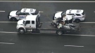
Baby, grandparents among 4 people killed in wrong-way police chase on Ontario's Hwy. 401
A police chase which started with a liquor store robbery in Bowmanville Monday night ended in tragedy some 20 minutes later when a suspect fleeing police entered Highway 401 in the wrong direction and caused a pileup which killed an infant and the child's grandparents, as well as the suspect, investigators say.
Air Canada walks back new seat selection policy change after backlash
Air Canada has paused a new seat selection fee for travellers booked on the lowest fares just days after implementing it.
McGill requests 'police assistance' over pro-Palestinian encampment
McGill University says it has 'requested police assistance' about the pro-Palestinian encampment on its lower field.
Judge raises threat of jail in hush money trial as he holds Trump in contempt, fines him US$9,000
Donald Trump was held in contempt of court Tuesday and fined US$9,000 for repeatedly violating a gag order that barred him from making public statements about witnesses, jurors and some others connected to his New York hush money case. And if he does it again, the judge warned, he could be jailed.
Court upholds Milwaukee police officer's firing for posting racist memes after Sterling Brown arrest
The Wisconsin Supreme Court ruled Tuesday that a former Milwaukee police officer was properly fired for posting racist memes related to the arrest of an NBA player that triggered a public outcry.
Video captures deadly wrong-way police chase on Highway 401 in Ontario
A new video has surfaced showing a vehicle being pursued by police in the wrong direction on Highway 401 moments prior to a fatal crash that killed four people, including an infant and their grandparents.
New cancer treatment approved, but not everyone thinks it's what's best for patients
A new cancer treatment recently approved in Canada promises to cut treatment time down to just minutes, but experts have differing opinions on whether it's what's best for patients.
Shopping Trends
The Shopping Trends team is independent of the journalists at CTV News. We may earn a commission when you use our links to shop. Read about us.


Kitchener
-
 BREAKING
BREAKING Shooting reported in Kitchener neighbourhood
Ornge says they’ve airlifted one person to hospital after a shooting in Kitchener.
-
Conestoga is a foreign student mecca. Is its climb to riches leading it off a cliff?
Aggressive international recruitment has brought in a flood of new money, but questions are also being raised within the institution about the sustainability of that growth, and the motivations behind it.
-
Guelph, Ont. senior loses $34,000 to benefits scam
A Guelph, Ont. woman in her late 60s has lost $34,000 after falling victim to a Facebook scam.
London
-

'There are going to be some real issues in terms of enforcement': Parents weigh in on school cellphone ban
The debate around the Ford government cellphone ban in schools continues to stir. Parents and professional educators are weighing in with potential pros and pitfalls.
-
Homeowner finds woman sleeping in their northeast London home
London police have charged a woman after they say a person found a stranger sleeping in their home.
-
Over 1,500 students in Huron-Perth sent suspension notices
The Huron Perth Public Health Unit has issued 1,557 suspension orders to students in elementary and secondary school whose immunization records are considered incomplete.
Barrie
-
Popular assassin game startles Collingwood residences
An assassin game turns into a dangerous reality for police who respond to two reports of teens allegedly carrying firearms in broad daylight.
-
Suspect accused of making threats and refusing to leave a home
Police responded to a call on Monday night after receiving reports of an individual allegedly making threats and refusing to leave a home.
-
Police seek help in determining how a young man died in Blue Mountains crash
OPP is investigating a single vehicle crash in the Blue Mountains that claimed the life of one person.
Northern Ontario
-
Baby, grandparents among 4 people killed in wrong-way police chase on Ontario's Hwy. 401
A police chase which started with a liquor store robbery in Bowmanville Monday night ended in tragedy some 20 minutes later when a suspect fleeing police entered Highway 401 in the wrong direction and caused a pileup which killed an infant and the child's grandparents, as well as the suspect, investigators say.
-
Sudbury assault victim struck, tied to a chair and robbed, police say
Sudbury police say they are investigating after a man was allegedly assaulted at a home on Lourdes Street early Tuesday morning.
-
After car chase, young driver in Sudbury tries to run away from police
A 20-year-old suspect in Sudbury was arrested last week after trying to escape from police responding to reports of erratic driving.
Sault Ste. Marie
-
Province boosts northern travel grant, eases restrictions, increases payouts
The Ontario government is spending $45 million in the next three years to improve access and funding for the northern travel grant.
-
Algoma Steel worker injured when water hit molten slag
A worker was treated on-site at Algoma Steel on Monday when a fire broke out in a piece of equipment.
-
Plenty of smiles at Tim Hortons across Canada
The Smile Cookie campaign kicked off at Tim Hortons locations across northeastern Ontario on Monday.
Ottawa
-

Costs associated with youth eating disorders reached $39.5 million during COVID pandemic, study suggests
Researchers at Ottawa's CHEO Research Lab are calling for a national surveillance strategy on eating disorders in Canada, as new statistics show a rise in the social and economic costs associated with the issue in children and youth.
-
Baby, grandparents among 4 people killed in wrong-way police chase on Ontario's Hwy. 401
A police chase which started with a liquor store robbery in Bowmanville Monday night ended in tragedy some 20 minutes later when a suspect fleeing police entered Highway 401 in the wrong direction and caused a pileup which killed an infant and the child's grandparents, as well as the suspect, investigators say.
-
Quebec man facing charges in two grandparent scams in Cornwall, Ont., police say
A Quebec resident is facing charges in connection to two alleged grandparent scams in Cornwall, Ont. over the past two months.
Toronto
-
Baby, grandparents among 4 people killed in wrong-way police chase on Ontario's Hwy. 401
A police chase which started with a liquor store robbery in Bowmanville Monday night ended in tragedy some 20 minutes later when a suspect fleeing police entered Highway 401 in the wrong direction and caused a pileup which killed an infant and the child's grandparents, as well as the suspect, investigators say.
-
Video captures deadly wrong-way police chase on Highway 401 in Ontario
A new video has surfaced showing a vehicle being pursued by police in the wrong direction on Highway 401 moments prior to a fatal crash that killed four people, including an infant and their grandparents.
-
Peel police bust 'high-end' vehicle-dismantling operation in Mississauga
A number of "high-end" stolen vehicles were found in Mississauga earlier this month and police say four suspects were in the process of breaking the cars down and selling the parts before their arrest.
Montreal
-
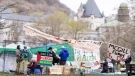
McGill requests 'police assistance' over pro-Palestinian encampment
McGill University says it has 'requested police assistance' about the pro-Palestinian encampment on its lower field.
-
Quebec solidaire MNAs come to defence of parliamentary leader after shock resignation
In the wake of the resignation of their co-spokesperson Émilise Lessard-Therrien, elected representatives of Québec solidaire (QS) have come to the defence of their parliamentary leader Gabriel Nadeau-Dubois.
-
Transit fares are going up in the Montreal area. Here's the new price structure
Transit riders, take note: the Montreal-area regional transit authority, the ARTM, is changing its fare structure on July 1. Prices are going up by an average of 3 per cent.
Winnipeg
-
Lawyers for alleged Winnipeg serial killer point to opinion poll in bid to get jury tossed
The lawyers of an alleged serial killer in Winnipeg are questioning whether pre-trial publicity in the high-profile case may have influenced the jury’s decision-making ability, after a public poll commissioned by the defence found 81 per cent of respondents believe the accused is guilty.
-
Canada-wide warrants issued for 19-year-old man in connection with Edmonton extortions, Winnipeg shooting
The Edmonton Police Service has issued Canada-wide warrants for a man believed to be involved in an ongoing extortion investigation in Edmonton, as well as a shooting in Winnipeg.
-
Safety summit to focus on root causes of crime in Manitoba
A safety summit is underway in Manitoba to help the province develop a plan to address crime.
Edmonton
-

Canada-wide warrants issued for 19-year-old man in connection with Edmonton extortions, Winnipeg shooting
The Edmonton Police Service has issued Canada-wide warrants for a man believed to be involved in an ongoing extortion investigation in Edmonton, as well as a shooting in Winnipeg.
-
Josh Classen's forecast: Cool, windy and some mixed precipitation
Rain moved into the Edmonton area overnight and we'll continue to see some precipitation through the morning hours.
-
Free Eco Station and Big Bin weekend events coming back to Edmonton
The City of Edmonton is organizing free Big Bin and Eco Station events throughout the summer.
Calgary
-

Three Calgary massage parlours closed over alleged link to human trafficking
Police have closed three Calgary massage parlours after a year-long investigation uncovered alleged links to human trafficking.
-
Thousands without power as heavy snow blankets Calgary
Heavy, wet snow is causing problems Tuesday morning, including knocking out power for thousands of people.
-
2024 Calgary Folk Music Festival lineup unveiled
The Roots, Cowboy Junkies and Ben Howard are among the acts performing at the 2024 Calgary Folk Music Festival.
Regina
-
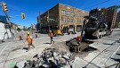
Here are Regina's main projects for the 2024 construction season
As Regina’s construction season officially kicks off for 2024 – here’s where residents can expect to see crews and traffic restrictions this summer.
-
CRIME STOPPERS
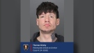
CRIME STOPPERS Regina police release photo of suspect believed to have started Cornwall Centre fire
Regina police have released a photo of the suspect they believe is involved in the arson at the Cornwall Centre mall on April 10.
-
Here's Saskatchewan's 10 'worst roads'
The top 10 'worst roads' in Saskatchewan include four streets in Moose Jaw and three different highways around the province.
Vancouver
-

London Drugs stores remain closed, 'cybersecurity incident' may have breached personal data
London Drugs says it is working with third-party security experts as the company tries to reopen dozens of stores across Western Canada that were shuttered by a cybersecurity incident Sunday.
-
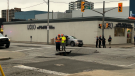
Mounties investigating after man found shot in Langley, B.C.
Mounties are investigating after a man with a gunshot wound was found on the side of the road in Langley, B.C., early Tuesday morning.
-
47 charges laid against 5 men after investigation that started as 'small' fuel fraud case, Delta police say
Five men are facing a total of 47 charges after a police investigation in Delta that resulted in the seizure of more than $1 million worth of drugs last year, local police say.
Vancouver Island
-
London Drugs stores remain closed, 'cybersecurity incident' may have breached personal data
London Drugs says it is working with third-party security experts as the company tries to reopen dozens of stores across Western Canada that were shuttered by a cybersecurity incident Sunday.
-
Mounties investigating after man found shot in Langley, B.C.
Mounties are investigating after a man with a gunshot wound was found on the side of the road in Langley, B.C., early Tuesday morning.
-
47 charges laid against 5 men after investigation that started as 'small' fuel fraud case, Delta police say
Five men are facing a total of 47 charges after a police investigation in Delta that resulted in the seizure of more than $1 million worth of drugs last year, local police say.
Atlantic
-
Police searching for 'armed man' in Dartmouth, N.S., residents asked to shelter in place
Residents in the area of Gaston Road in Dartmouth, N.S., are being asked to shelter in place as police search for an armed suspect.
-
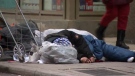
Man held captive for two days at encampment: Saint John police
Police in Saint John, N.B., say a man was assaulted and held captive at an encampment in the city last week.
-
3 Halifax-area schools dismissed early Tuesday following alleged threats
Halifax Regional Centre for Education says students at three schools were dismissed early Tuesday following threats.
N.L.
-

'I feel honoured to say I was his friend': Wayne Gretzky remembers Bob Cole
Tributes continue to pour in for Bob Cole as his family has confirmed a funeral will be held for the legendary broadcaster Friday in St. John's, N.L.
-
Voice of 'Hockey Night in Canada' Bob Cole never considered moving out of St. John's
Legendary sportscaster Bob Cole was a Newfoundlander through and through, and his daughter says his connection to the province was 'everything' to him.
-
Cenovus fined $2.5 million for biggest oil spill in Newfoundland and Labrador history
Cenovus Energy has been ordered to pay a $2.5-million fine for its role in the largest offshore oil spill ever recorded in Newfoundland and Labrador.


