Possibility of 'flash freeze' on the way
The special weather statement remains in effect for Windsor-Essex, Chatham-Kent and all of southern Ontario.
A major winter storm is still on track to move into the area starting late Thursday as rain or snow and transitioning to rain Thursday night.
Temperatures are also expected to plummet on Friday, leading to a potential flash freeze for areas that receive the rainfall.
Wednesday: A mix of sun and cloud. Wind up to 15 km/h. High minus 1. Wind chill minus 10 this morning and minus 3 this afternoon
Wednesday Night: Partly cloudy. Wind up to 15 km/h. Low minus 2 with temperature rising to plus 1 by morning. Wind chill minus 6 this evening.
Thursday: Cloudy. 70 per cent chance of rain or drizzle in the afternoon. Wind south 30 km/h. High plus 4.
Friday: Periods of snow. Blowing snow. Windy. High minus 3.
Saturday: Cloudy with 40 per cent chance of flurries. Local blowing snow. Windy. High minus 8.
Sunday: A mix of sun and cloud with 40 per cent chance of flurries. Windy. High minus 9.
Monday: A mix of sun and cloud. High minus 6.


CTVNews.ca Top Stories

India's foreign minister reacts to murder charges, claims Canada welcomes criminals
India's Foreign Affairs Minister accused Canada of welcoming criminals from his country in response to the RCMP's recent arrests in a homicide that has roiled tensions between the two countries.
15-year-old boy stabbed in Ottawa on Thursday dies
A 15-year old boy who was critically injured after a stabbing in Nepean on Thursday has died of his injuries, Ottawa's English public school board said Sunday.
Dash cam catches moment suspected drunk driver hits parked car, sends it careening into North Shore flower shop
Police say it’s fortunate no one was injured or killed in a collision at North Vancouver’s Park and Tilford shopping centre Saturday evening that sent one vehicle careening into a flower shop and another into a set of concrete barriers outside a Winners store.
Actor Bernard Hill, of 'Titanic' and 'Lord of the Rings,' has died at 79
Actor Bernard Hill, who delivered a rousing cry before leading his people into battle in 'The Lord of the Rings: The Return of the King' and went down with the ship as the captain in 'Titanic,' has died.
'A tiny city:' Pro-Palestinian campus protesters organize for another week
Pro-Palestinian activists have set up tents at universities in Toronto, Ottawa, Vancouver and Montreal, following a wave of similar protests at campuses in the United States linked to the Israel-Hamas war.
Lawsuit against Meta asks if Facebook users have right to control their feeds using external tools
Do social media users have the right to control what they see — or don't see — on their feeds?
A Holocaust survivor will mark that history differently after the horrors of Oct. 7
This year's Holocaust Remembrance Day, which begins on Sunday evening in Israel, carries a heavier weight than usual for many Jews around the world.
Princess Anne lays wreath at Battle of Atlantic ceremony; honours late Queen
Princess Anne saluted Canadian veterans and current forces members and honoured her late mother during separate ceremonies Sunday in Victoria as she wrapped up a three-day British Columbia West Coast royal visit.
El Nino weakening doesn't mean cooler temperatures this summer, forecasters say
As Canadians brace themselves for summer temperatures, forecasters say a weakening El Nino cycle doesn’t mean relief from the heat.
Shopping Trends
The Shopping Trends team is independent of the journalists at CTV News. We may earn a commission when you use our links to shop. Read about us.


Kitchener
-

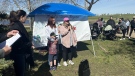
Event in Kitchener honours Missing and Murdered Indigenous people on Red Dress Day
A solemn event was held in Kitchener to honour Missing and Murdered Indigenous Women, Girls, and Two-Spirit people.
-
'It was completely underwater': Cambridge community remembers devastating flood 50 years later
May 17, 1974 started off like any other sunny spring day, but it very quickly turned into a day of disaster.
-
Most-read stories of the week: a hitch in truck repairs, WRDSB to lay off teachers, Arnold Schwarzenegger in Elora
A family frustrated over a hitch in their truck repair problems, elementary school teachers could be out of a job, and a Hollywood heavyweight in Elora.
London
-
 PLAYOFF TRACKER
PLAYOFF TRACKER Knights are Western Conference champs
The London Knights are Western Conference champions for the second straight year!
-
Successful search and rescue by LFD in vacant building fire
The London Fire Department (LFD) received a call about a reported structure fire at the former McCormick’s building at 1156 Dundas St.
-
REDress Day being recognized in Victoria Park
May 5 is REDress Day, held annually to raise awareness of missing and murdered Indigenous women, girls and two spirit+ people in Canada.
Barrie
-

Military personnel gather in Barrie to honour lives lost in Battle of the Atlantic
Local military troops held an annual parade and ceremony to commemorate the 79th anniversary of the Battle of the Atlantic.
-
Hundreds of families take part in Matthews House hike for hospice
The 15th annual Matthews House hike for hospice was held on Sunday.
-
One person injured in rollover crash in Barrie
One person is in hospital after a single-vehicle rollover in Barrie on Saturday.
Northern Ontario
-

Battalion trample Generals in Game 6, forcing deciding Game 7
The North Bay Battalion have beaten the Oshawa Generals 8-1 at home to push their OHL Eastern Conference Championship series to a Game 7.
-
El Nino weakening doesn't mean cooler temperatures this summer, forecasters say
As Canadians brace themselves for summer temperatures, forecasters say a weakening El Nino cycle doesn’t mean relief from the heat.
-
Crash closes Hwy 101 in Timmins
Highway 101 East in Timmins is closed in both directions due to a single-vehicle crash.
Sault Ste. Marie
-

Ontario to increase fines for employment standards violations
Ontario is set to clamp down on bad employers with big fines.
-
Police lay second-degree murder charge in northwestern Ont.
Ontario Provincial Police, in partnership with the Treaty Three Police Service, have charged a suspect with second degree murder following a homicide in a remote Indigenous northwestern Ontario community.
-
Health coalition calls on public to stand up for health care
The de-rostering of thousands of patients at the Group Health Centre in Sault Ste. Marie was the centre of attention at a town hall Friday organized by the Algoma chapter of the Ontario Health Coalition.
Ottawa
-
 BREAKING
BREAKING Woman in critical condition, 2 pets dead after apartment fire near Lebreton Flats
A woman was taken to hospital in critical condition following a fire that broke out in an apartment unit near Lebreton Flats on Sunday evening.
-
15-year-old boy stabbed in Ottawa on Thursday dies
A 15-year old boy who was critically injured after a stabbing in Nepean on Thursday has died of his injuries, Ottawa's English public school board said Sunday.
-
Ottawa trio to represent Team Ontario in acrobatic gymnastics competition
To be the best you have to train like the best, and that’s exactly what one acrobatic gymnastics trio is doing in Ottawa.
Toronto
-

Ontario family says they're 'reeling' after baby, grandparents killed in wrong-way Highway 401 crash in Whitby
An Ontario family says they are 'reeling' in 'profound grief' after losing their three-month-old son and parents visiting from India in a wrong-way crash on Highway 401 in Whitby last Monday.
-
Nylander defends Leafs' core after playoff exit, Toronto again picks up the pieces
The Maple Leafs battled back from a 3-1 series deficit against the Boston Bruins with consecutive 2-1 victories - including one that required extra time - in their first-round playoff series to push the club's Original Six rival to the limit before suffering a devastating Game 7 overtime loss.
-
Maple Leafs star Auston Matthews among finalists for NHL Selke Trophy
Toronto Maple Leafs star centre Auston Matthews is a finalist for the NHL's Selke Trophy.
Montreal
-
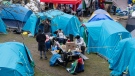
'A tiny city:' Pro-Palestinian campus protesters organize for another week
Pro-Palestinian activists have set up tents at universities in Toronto, Ottawa, Vancouver and Montreal, following a wave of similar protests at campuses in the United States linked to the Israel-Hamas war.
-
Montreal organizations say the housing crisis is the leading cause of stress in psychiatric patients
The housing crisis is having a severe impact on tenants' mental health, say organizations calling on Quebec Premier François Legault to take action.
-
Montreal's Jewish community remembers victims for Yom HaShoah: Holocaust Remembrance Day
On Sunday night, Jewish communities recognize Yom HaShoah, Holocaust Remembrance Day, where six candles are lit at a ceremony at the Montreal Holocaust Museum, one for every million Jews killed during the Holocaust.
Winnipeg
-

Manitoba government launches $15M endowment fund for MMIWG2S families
Families of Missing and Murdered Indigenous Women, Girls and Two-Spirit peoples can expect more financial support from the Manitoba government as part of a new endowment fund announced Sunday.
-
22-year-old Winkler man charged with manufacturing, possessing illegal weapons: police
A 22-year-old man from Winkler, Man., is facing several charges in connection with a large seizure of weapons, including a homemade cannon.
-
Community bake sale sees sweet support for Manitoba teen battling brain cancer
A Manitoba teen’s dream of dining in Parisian cafes is about to come true with some help from The Dream Factory.
Edmonton
-

Oilers to play Game 1 vs. Canucks on Wednesday
The Edmonton Oilers will play Game 1 of their second-round series against the Canucks in Vancouver on Wednesday.
-
2 suspects arrested following south Edmonton shooting: police
Two suspects were arrested following a shooting in south Edmonton on Saturday night.
-
'Come together': Families, survivors remember the missing and murdered on Red Dress Day in Alberta
Events were held across Alberta on Sunday marking Red Dress Day to honour the memory of missing and murdered Indigenous women and girls.
Calgary
-
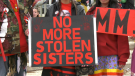
'Come together': Families, survivors remember the missing and murdered on Red Dress Day in Alberta
Events were held across Alberta on Sunday marking Red Dress Day to honour the memory of missing and murdered Indigenous women and girls.
-
Crews battle 'large' natural gas-fed fire at Marlborough home
Fire crews responded to Marlborough late on Saturday night to battle a blaze that had engulfed a home.
-
Serious collision impacts traffic along Highway 2A near Aldersyde
Emergency crews are on scene of a serious collision on Highway 7 at 32 Street East in Okotoks.
Regina
-
Regina hosts first 'Flora's Walk' in support of perinatal mental health
Sunday marked the first time Regina has taken part in an event that originated out of Ontario following the death of a new mother.
-
RCMP Heritage Centre hosts Red Dress Day event
May 5th marks Red Dress Day, a nationally recognized date that honours the lives of the many missing and murdered Indigenous women, girls and two-spirit people. In Regina, an event was held at the RCMP Heritage Centre to highlight the date and educate the public.
-
Sask. RCMP warns of increased police presence in Swift Current
Saskatchewan RCMP are asking the public to avoid areas of Swift Current due to an ongoing investigation.
Vancouver
-

'A very heavy day': Dozens attend Red Dress Day ceremony in Pitt Meadows
Red dresses dotted šxʷhék̓ʷnəs, or Spirit Square, in Pitt Meadows Sunday to honour the thousands of missing and murdered Indigenous women, girls and two-spirit people in Canada.
-
Dash cam catches moment suspected drunk driver hits parked car, sends it careening into North Shore flower shop
Police say it’s fortunate no one was injured or killed in a collision at North Vancouver’s Park and Tilford shopping centre Saturday evening that sent one vehicle careening into a flower shop and another into a set of concrete barriers outside a Winners store.
-
British Columbian homeowners born in the 1990s most likely in Canada to co-own with their parents: StatsCan
British Columbians born in the 1990s are more likely to co-own a home with their parents than anywhere else in the country, a new report from Statistics Canada has revealed.
Vancouver Island
-
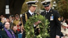
Princess Anne lays wreath at Battle of Atlantic ceremony; honours late Queen
Princess Anne saluted Canadian veterans and current forces members and honoured her late mother during separate ceremonies Sunday in Victoria as she wrapped up a three-day British Columbia West Coast royal visit.
-
London Drugs begins 'gradual reopening' on 7th day after cyberattack
Almost a week after all London Drugs stores across Western Canada abruptly closed amid a cyberattack, they began a "gradual reopening" on Saturday.
-
British Columbian homeowners born in the 1990s most likely in Canada to co-own with their parents: StatsCan
British Columbians born in the 1990s are more likely to co-own a home with their parents than anywhere else in the country, a new report from Statistics Canada has revealed.
Atlantic
-

Three dead, two hospitalized, following collision in Fredericton: police
Three people have died and two have been hospitalized after a speeding car struck a tree and landed on another vehicle in Fredericton Sunday morning.
-
Man in custody following weapons-related incident at Halifax hotel: police
A man is in custody after a weapons-related incident at a Halifax hotel Sunday morning.
-
P.E.I.'s East Pointers lead pack with total of three wins at East Coast Music Awards
P.E.I.'s The East Pointers are multiple winners as the East Coast Music Awards wrapped up today in Charlottetown.
N.L.
-

Funeral today for broadcasting legend and voice of 'Hockey Night in Canada' Bob Cole
A funeral is being held today for hockey broadcasting legend Bob Cole in his hometown of St. John's, N.L.
-
Newfoundland fisherman says police broke his leg during protest that delayed budget
Richard Martin is spending this year's fishing season on land after he says a Royal Newfoundland Constabulary officer broke his left leg in three places during a protest last month that shut down the provincial legislature.
-
'I feel honoured to say I was his friend': Wayne Gretzky remembers Bob Cole
Tributes continue to pour in for Bob Cole as his family has confirmed a funeral will be held for the legendary broadcaster Friday in St. John's, N.L.


