Winter storm warning: snowfall intensifies in Windsor-Essex
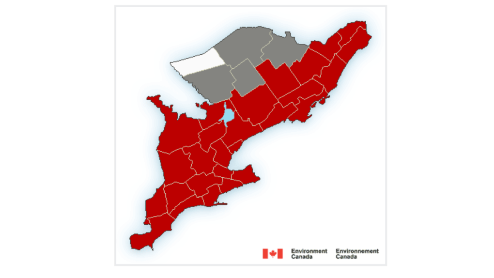
Environment Canada says most areas could see upwards of 15 cm of accumulation of snow with reduced visibility on the roads.
While the snowy weather is hazardous for drivers, many pets and kids appeared to be enjoying the winter weather.
PHOTO GALLERY: Snow in Windsor-Essex
It’s a snow day for many students. No school buses are running in Windsor-Essex, but schools are open. According to the Bus Planner website, Area A - City of Windsor - all board provided transportation is cancelled for the day and Area B - County of Essex - all board provided transportation is cancelled for the day.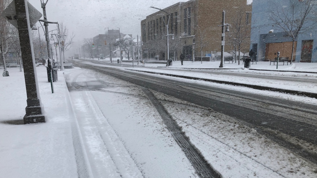 Snow falls on the sidewalks and streets in Windsor, Ont. (Gary Archibald/CTV News Windsor)
The system impacting this region is reportedly a Texas low that will bring heavy snow to the area beginning Wednesday morning.
The snowfall intensified by afternoon. Heavy snow is expected to taper off to flurries overnight with a couple of additional centimetres will be possible on Thursday. At 3 p.m. Wednesday, police reported multiple accidents in the area of Howard Ave at Division Rd. No injuries were reported at the time.
The weather authority is also warning to prepare for quickly changing and deteriorating travel conditions adding, there may be a significant impact on rush hour traffic in urban areas.
With Environment Canada forecasting a steady snowfall to continue through early Thursday morning, the city says snow crews are working hard to clear the main routes.
The city says enough snow has fallen to warrant residential snow clearing and plowing. Crews will begin working in neighbourhoods early Thursday morning once the main arterial routes have been cleared.
The city is asking for patience as clearing can be a slow process and typically takes 24 to 36 hours to complete.
Drivers are asked to use extra when approaching intersections due to slippery conditions and to be patient when travelling behind a snow plow.
 (Source: Environment Canada)Wednesday: Snow at times heavy. Amount 10 cm. Wind becoming east 20 km/h gusting to 40 this morning. Temperature steady near zero.
Wednesday Night: Snow ending near midnight then cloudy with 60 per cent chance of flurries. Amount 2 to 4 cm. Wind north 20 km/h becoming west 20 late this evening. Temperature steady near zero.
Thursday: Cloudy with 60 per cent chance of flurries. Wind northwest 20 km/h becoming light in the morning. Temperature steady near zero.
Friday: Cloudy with 30 per cent chance of flurries. High minus 1.
Saturday: A mix of sun and cloud with 30 percent chance of flurries. High zero.
Sunday: Periods of snow. High minus 3.
Monday: A mix of sun and cloud with 40 per cent chance of flurries. High minus 5.


CTVNews.ca Top Stories

BREAKING
BREAKING Israel attacks Iran, Reuters sources say; drones reported over Isfahan
Israel has attacked Iran, three people familiar with the matter told Reuters, as Iranian state media reported early on Friday that its forces had destroyed drones, days after Iran launched a retaliatory drone strike on Israel.
American millionaire Jonathan Lehrer denied bail after being charged with killing Canadian couple
American millionaire Jonathan Lehrer, one of two men charged in the killings of a Canadian couple in Dominica, has been denied bail.
Nearly half of China's major cities are sinking, researchers say
Nearly half of China's major cities are suffering 'moderate to severe' levels of subsidence, putting millions at risk of flooding especially as sea levels rise.
Prince Harry formally confirms he is now a U.S. resident
Prince Harry, the son of King Charles III and fifth in line to the British throne, has formally confirmed he is now a U.S. resident.
Judge says 'no evidence fully supports' murder case against Umar Zameer as jury starts deliberations
The judge presiding over the trial of a man accused of fatally running over a Toronto police officer is telling jurors the possible verdicts they may reach based on the evidence in the case.
Health Canada to change sperm donor screening rules for men who have sex with men
Health Canada will change its longstanding policy restricting gay and bisexual men from donating to sperm banks in Canada, CTV News has learned. The federal health agency has adopted a revised directive removing the ban on gay, bisexual and other men who have sex with men, effective May 8.
Colin Jost names one celebrity who is great at hosting 'Saturday Night Live'
Colin Jost, who co-anchors Saturday Night Live's 'Weekend Update,' revealed who he thinks is one of the best hosts on the show.
Sports columnist apologizes for 'oafish' comments directed at Caitlin Clark. The controversy isn't over
A male columnist has apologized for a cringeworthy moment during former University of Iowa superstar and college basketball's highest scorer Caitlin Clark's first news conference as an Indiana Fever player.
'Shopaholic' author Sophie Kinsella reveals brain cancer diagnosis
Sophie Kinsella, the best-selling author behind the 'Shopaholic' book series, has revealed that she is receiving treatment for brain cancer.
Shopping Trends
The Shopping Trends team is independent of the journalists at CTV News. We may earn a commission when you use our links to shop. Read about us.


Kitchener
-

Landlords reporting increase in tenants refusing to pay rent or leave
A property management company in Fergus is still cleaning up after they say a tenant trashed one of their units and refused to pay rent -- and they say it's not the only similar case they've dealt with recently.
-
Gas price hike blamed on change in seasons, motorists 'shocked'
Gas prices across Ontario have spiked to levels not seen in nearly two years as the switch from winter fuel to a more expensive summer blend pushes the price at the pumps.
-
What are these things doing in Waterloo Park?
Don’t be alarmed if you see some strange new creatures in Waterloo Park.
London
-

'Mistakes happen': Health minister says patients have recourse if charged inappropriately
The provincial government is advising there is recourse for those who believe they've been wrongfully billed for healthcare services.
-
Witness alleges years of severe abuse at the hands of parents
A jury heard some horrific evidence Thursday at the trial of a London, Ont. couple charged with physically and sexually abusing their children.
-
Mourning loss of affordable housing in London
Members of London Acorn chanted slogans and called for urgent action from all levels of government to prevent the loss of affordable housing units.
Barrie
-

Driver suffers life-threatening injuries in Hwy 12 collision
One person suffered life-threatening injuries after a collision with a commercial vehicle on Highway 12 at Forest Avenue in Orillia early Thursday afternoon.
-
Surviving the economic vortex: How restaurants can weather inflation's storm
As inflation tightens its grip on the economy, many people are feeling the pinch, from housing to transportation to retail and services, including restaurants.
-
Discreditable conduct Police Services Act hearing for Barrie police veteran
The hearing for a Barrie police officer charged with discreditable conduct following an OPP investigation continued Thursday morning over teleconference.
Northern Ontario
-

Private Northern Ont. college accused of taking tuition, but not offering courses
A private career college in North Bay is under intense scrutiny from students for taking tuition but not offering courses, and from former teachers who say they haven't been paid.
-
State of emergency still in effect in northern communities
Some communities in northeastern Ontario remain under a state of emergency due to last Friday’s rain.
-
Parry Sound man among those falsely told by Tim Hortons that they won a boat
Tim Hortons says human error is to blame for some customers thinking they had won a boat in a recent digital roll up to win contest.
Sault Ste. Marie
-

Northern Ont. woman wins big with gifted lottery scratch ticket
A 65-year-old northern Ontario woman says her winning lottery scratch ticket is the best present she has ever received.
-
Small northern Ont. town loses access to mobile cancer screening
A northern Ont. city councillor says she fears many women will go without the proper health care after town loses access to mobile cancer screening.
-
Sault cracking down on people who misuse accessible parking spots
For the next several months, the City of Sault Ste. Marie will be cracking down on people who improperly use accessible parking spaces.
Ottawa
-

1 dead following wrong-way crash on Hwy. 417 in Ottawa's east end
The driver killed in a head-on crash on Hwy. 417 in Ottawa's east end was driving eastbound in the westbound lanes when the vehicle collided with a second vehicle, according to Ontario Provincial Police.
-
Barrhaven's mass killing suspect appears in court Thursday, here's what's new
The suspect accused of murdering six people at a home in Barrhaven made another brief court appearance Thursday afternoon.
-
GAS PRICES
GAS PRICES Here's when gas prices will drop 4 cents a litre in Ottawa
Canadians for Affordable Energy president Dan McTeague says gas prices will drop 4 cents a litre on Friday, one day after prices increased 14 cents a litre.
Toronto
-

Grandparent scam suspects had ties to Italian organized crime, police allege
A group of suspects that allegedly defrauded seniors across Ontario and other parts of Canada using a so-called emergency grandparent scam appear to have ties to 'Italian traditional organized crime,' according to an investigator involved in the OPP-led probe.
-
'He left a mark in this world': Thorncliffe Park teen who drowned in Lake Ontario remembered
He was a loving son and brother, a loyal and kind friend, and a dedicated volunteer in Toronto’s east end, say those who knew and loved Mohammad Khasim.
-
Cat found on Toronto Pearson airport runway 3 days after going missing
Kevin the cat has been reunited with his family after enduring a harrowing three-day ordeal while lost at Toronto Pearson International Airport earlier this week.
Montreal
-

Quebec judge suspends parts of Bill 96 that apply to English school boards
The English Montreal School Board (EMSB) is celebrating what it calls a 'significant win' in court after a judge stayed parts of Quebec's language laws that apply to English school boards across the province.
-
Quebec to follow Ottawa's lead on capital gains taxation
Quebec intends to follow Ottawa's lead and increase its capital gains tax rate. The Quebec government announced late on Thursday that its tax system will be adjusted to bring it into line with five measures proposed in the latest federal budget.
-
American millionaire Jonathan Lehrer denied bail after being charged with killing Canadian couple
American millionaire Jonathan Lehrer, one of two men charged in the killings of a Canadian couple in Dominica, has been denied bail.
Winnipeg
-

'It could be catastrophic': Woman says natural supplement contained hidden pain killer drug
A Manitoba woman thought she found a miracle natural supplement, but said a hidden ingredient wreaked havoc on her health.
-
'This is an eyesore': City charting plan to clean giant debris left for two years on Sherbrook Street
The City of Winnipeg is finally moving ahead with a plan to clear away a large pile of debris on a private lot.
-
'This program has saved lives': New report highlights success of Mobile Overdose Prevention Site during first year of operation
The Mobile Overdose Prevention Site operated by Sunshine House has been in operation since late 2022, and now a report is being released sharing the results of its first year.
Edmonton
-

Alberta introducing legislation to stabilize electricity rates, educate customers about RRO
Alberta is introducing new legislation aimed at preventing spikes in electricity prices.
-
'It hurts': Edmonton man frustrated after false Roll up the Rim win
An Edmonton man is feeling let down after Tim Hortons mistakenly told him he'd won a boat.
-
Worker dies after fall at north Edmonton construction site
Occupational Health and Safety (OHS) is investigating after a worker fell to their death earlier this week.
Calgary
-

'One of the brightest little girls I know': Family of Calgary toddler killed in 2022 speaks out
Calgary police say Winston Campbell, 45, has been charged in the death of a two-year-old girl in 2022.
-
Flames earn 5-1 season-ending victory over league-worst Sharks
Blake Coleman scored his 30th goal and MacKenzie Weegar got his 20th as the Calgary Flames set multiple personal milestones in a season-ending 5-1 victory over the San Jose Sharks on Thursday night.
-
Calgary Taylor Swift fans – and 'Calgary Taylor Swift' – celebrate album drop
Calgary fans of pop superstar Taylor Swift were among the millions of 'Swifties' celebrating the release of 'The Tortured Poets Department', and they were doing it in style.
Regina
-

'Poor choice of words': Education Minister apologizes for remarks made to Sask. mother
On Thursday, Education Minister Jeremy Cockrill apologized for remarks he made to a mother who had advocated for better classroom supports earlier this week.
-
Sask. dental providers and seniors raise concerns over federal dental care plan
With the Canadian Dental Care Plan (CDCP) set to roll out on May 1, many dental care providers have concerns and unanswered questions about the plan.
-
'Bad taste in your mouth': Regina man mistakenly told he won $50K boat through Roll up the Rim
Chris Ross was pleasantly surprised when Tim Hortons sent him an email summarizing his "Roll up the Rim" winnings for the season. The email claimed Ross had won a boat valued at over $50,000 – but it was a mistake.
Vancouver
-

B.C. premier defends drug decriminalization as controversy grows, feds scrutinize program
The premier of British Columbia is continuing to defend the three-year pilot program underway in his province that’s decriminalized personal possession of hard drugs, even as the federal government sends its minister responsible to discuss growing concerns and controversies.
-
UBC football star turning heads in lead up to NFL draft
At 6'8" and 350 pounds, there is nothing typical about UBC offensive lineman Giovanni Manu, who was born in Tonga and went to high school in Pitt Meadows.
-
Delta police seek witnesses to rollover crash
Police in Delta are appealing for witnesses and information after a mid-afternoon rollover crash into the front yard of a home last week.
Vancouver Island
-
B.C. premier defends drug decriminalization as controversy grows, feds scrutinize program
The premier of British Columbia is continuing to defend the three-year pilot program underway in his province that’s decriminalized personal possession of hard drugs, even as the federal government sends its minister responsible to discuss growing concerns and controversies.
-
$60K worth of Indigenous art stolen in Saanich, B.C., police say
A large collection of First Nations art worth more than $60,000 was stolen in Saanich earlier this month, police announced Thursday.
-
B.C.'s short-term rental regulations include $10K daily penalties for Airbnb, other platforms
Short-term rental platforms that violate B.C.'s pending regulations can face administrative penalties of up to $10,000 per day, officials announced Thursday.
Atlantic
-

Nova Scotia premier says agreement reached with teachers union, strike averted
Nova Scotia Premier Tim Houston says an agreement in principle has been reached on a new contract for public school teachers.
-
N.S. justice minister apologizes for domestic violence comments
Nova Scotia's opposition parties are calling for the justice minister to resign after he said domestic violence is not an "epidemic."
-
Neighbours left frustrated after years of cows roaming free in N.B. area
Some residents in rural New Brunswick are frustrated with cows that roam into their properties.
N.L.
-

N.L. gardening store revives 19th century seed-packing machine
Technology from the 19th century has been brought out of retirement at a Newfoundland gardening store, as staff look for all the help they can get to fill orders during a busy season.
-
500 Newfoundlanders wound up on the same cruise and it turned into a rocking kitchen party
A Celebrity Apex cruise to the Caribbean this month turned into a rocking Newfoundland kitchen party when hundreds of people from Canada's easternmost province happened to be booked on the same ship.
-
Protest averted as Newfoundland and Labrador premier helps reach pricing deal on crab
A pricing agreement has been reached between crab fishers and seafood processors that will allow for Newfoundland and Labrador's annual crab fishery to get started.


